Portal Overlook in Moab: Big Views, Bold Drops & Your Tiny Home Basecamp

Portal Overlook in Moab: Big Views, Bold Drops & Your Tiny Home Basecamp

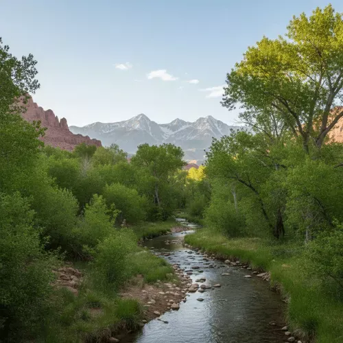
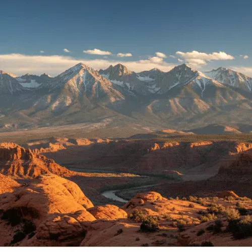
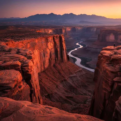
Most of the time in Moab, you are inside the landscape—threading through canyons, tucked beneath stone arches, dwarfed by walls of sandstone. But Portal Overlook flips the script. This is where you rise above it all. High on the cliffs west of town, the Portal offers one of Moab’s most staggering perspectives: thousand-foot drops, wide-open skies, and the whole valley spread out like a living map below. It is not just a view—it is vertigo with a side of awe. Portal Overlook Cabin is for the traveler who seeks that edge-of-the-world feeling… and then comes home to peace, quiet, and grounded comfort. Portal Overlook: Moab From the Edge Perched above the Colorado River along the Moab Rim, the Portal area delivers something few other trails in Moab can match: scale. Raw, dizzying, cinematic scale. Whether you hike up, ride in, or drive nearby, the payoff is the same: a 360-degree panorama that hits you in the gut. From the rim, you will see: The town of Moab unfolding below—tiny roads, tinier rooftops The Colorado River carving graceful curves through shadowed canyons Sheer sandstone cliffs plunging beneath your feet The La Sal Mountains rising distant and blue, often snow-dusted Ravens gliding past at eye level, their wings catching the updraft like poetry This is not a place you just look at. It is a place that looks back. How to Experience Portal Overlook Hiking the Moab Rim/Portal Trails (Advanced) The Portal Overlook can be reached by a network of rugged trails—steep, rocky, and not for the faint of heart. These climbs gain serious elevation fast and feature exposed sections with big consequences. If you are sure-footed and experienced, it is a route that rewards bravery with brilliance. Mountain Biking the Portal Trail (Expert Only) Portal is legendary in the MTB world—for both its views and its infamy. This is one of the most exposed bike trails in North America. Certain sections are so narrow and high-consequence that even pros dismount and walk. It is not about ego—it is about respect. Scenic Drives and Vantage Points (Everyone) Not ready for high-consequence cliffs? You can still enjoy the drama. Drive Potash Road (Highway 279) or Highway 191 for viewpoints of the Portal from below. Sunset from these lower angles is still pure magic. Important: This is serious terrain. If you are hiking or biking, know your limits. This is not an “Instagram and flip-flops” spot. What Nobody Tells You The photos do not do it justice. The height is disorienting in the best way. Even veteran hikers stop short when the exposure ramps up. That is not weakness—it is wisdom. Wind funnels along the cliff edge. What feels breezy at the trailhead can feel fierce at the top. The town glows at night from above—like looking down on stars. Just being near the edge—without going over it—is often enough. Why Portal Overlook Stays With You Portal does not just give you a new view. It gives you a new perspective—on space, scale, and your place in it. You will remember: That involuntary breath-in when the drop first appears. The way your shadow stretched out across a canyon wall. The river, snaking like molten silver through the dusk. It is one of those rare places that makes your brain whisper: “We are small.” And somehow, that feels exactly right. Stay at Portal Overlook Cabin After hours at altitude, your body craves ground. A place with warm light, soft textures, and zero drop-offs. That is why we named one of our tiny homes Portal Overlook Cabin. Located at 1251 Millcreek Dr, Moab, it is just minutes from the trailheads, scenic drives, and all the drama of the Portal Rim—but miles away in feeling. At Portal Overlook Cabin, you will find: A full kitchen for big breakfasts, post-hike cravings, and celebratory snacks A calm, modern space to review photos, stretch out sore legs, or just be still Climate control to reset after sun, wind, or a nerve-tingling climb A soft bed, blackout shades, and no alarms—you have earned the recharge You are minutes from: The Moab Rim and Portal trailheads Potash Road’s lower overlooks and pullouts Downtown Moab’s coffee, gear, food, and local wisdom If you are drawn to big views and bold trails—but crave serenity when the adrenaline fades—Portal Overlook Cabin is your perfect landing zone. Primary CTA button: Text: Check Availability for Portal Overlook Cabin URL: /cabins/portal-overlook Secondary CTA link: Text: Explore All Moab Tiny Homes → URL: /cabins Frequently Asked Questions Q: Is Portal Overlook safe? A: Yes—with caution. If you stay away from cliff edges, watch your footing, and know your limits, it can be an incredible experience. Never treat this terrain casually. Q: Can I enjoy the views without intense exposure? A: Absolutely. Scenic drives and lower pullouts along Potash Road give you gorgeous views from safer ground. Q: Is this a good area for beginners? A: Not the upper trails—they are for advanced users only. Beginners will enjoy lower elevation hikes and scenic drives nearby. Q: What gear do I need? A: For hiking: grippy shoes, plenty of water, sun protection, and offline maps. For biking: a capable mountain bike, helmet, serious skills—and a deep respect for drop-offs. Q: Is it dog- or kid-friendly? A: Only with extreme caution. Exposed cliffs plus little feet or paws equals high risk. Many families choose safer, nearby hikes instead. More Moab Adventures from Your Cabin → Moab Rim: Big Climb, Big View, Big Reward (/activities/moab-rim) → Corona Arch: The Underrated Stone Giant (/activities/corona-arch) → Sand Flats: Slickrock Playground & Sunrise Views (/activities/sand-flats) → Red Rock: The Iconic Moab Landscape (/activities/red-rock) → La Sal Mountains: Alpine Majesty & Desert Views (/activities/la-sal-mountains) → See All Moab Activity Guides → (/activities)

Portal Overlook in Moab: Big Views, Bold Drops & Your Tiny Home Basecamp

Pack Creek Near Moab: Cool Air, Cottonwoods & Your Tiny Home Basecamp

Most people come to Moab for the red rock. But if you stay long enough, you start to crave something else: Shade. Green. Cool air after hot stone. That’s where Pack Creek comes in. Tucked into the foothills of the La Sal Mountains, Pack Creek is where the desert exhales— where cottonwoods lean over running water, the breeze smells like pine, and the views trade slickrock drama for snow-dusted peaks and softer light. Pack Creek Cabin is for travelers who love canyon heat by day— but want their evenings wrapped in trees, silence, and cooler air. Pack Creek: Where Desert Meets Mountain Pack Creek sits southeast of Moab, along the lower slopes of the La Sals. It’s not a trailhead. It’s not a park. It’s a feeling—of slowing down, breathing deeper, and watching the land change tone. Here, you’ll find: A creek that winds through meadows and groves of trees Cottonwoods, willows, and aspens moving in the breeze Cooler air, especially in the mornings and evenings Wide-open views back toward the glowing red cliffs of Moab It’s where red rock meets green. Where canyon dust gives way to mountain air. Pack Creek Visit Guide: How to Experience It Pack Creek isn’t a “check-the-box” hike. It’s a shift in pace. A basecamp for slower mornings, scenic drives, and mountain wanderings. Scenic Drives Follow winding roads out of Moab and into the La Sal foothills. You’ll pass ranch land, old fences, cottonwood corridors, and ever-changing views of both peaks and mesas. Even just rolling the windows down feels like a reset. Creekside Wandering In places where access allows, stroll beside the water. Let the sounds of the creek and the rustling trees soften the desert intensity. (Always respect private land—much of this area is a patchwork of public and private.) Gateway to the La Sals Pack Creek puts you right on the doorstep of the La Sal Mountains. From here, you can: Head up into alpine trails Catch fall colors as they light the hills Or just pull over and watch sunlight and shadow roll across the range Best Times to Visit Late Spring → Water flowing, trees leafing out, wildflowers waking up Summer → A cooler haven from town heat, especially at sunrise and dusk Fall → Crisp air, golden leaves, red cliffs glowing behind it all Winter → Quiet, snow-dusted, and peaceful in a way few expect from Moab What Nobody Tells You → The sound of running water hits different after a day in dry canyons → You can frame snow and red rock in the same photo here—especially in spring and fall → Sunsets from this side of the valley? Unreal. Red cliffs glowing. Peaks in shadow. → It’s one of the best places to simply exhale—no epic trail required → On clear nights, the stars feel closer with no town lights in the way Why Pack Creek Stays With You Pack Creek isn’t a highlight reel. It’s a mood shift. It’s the part of the trip where your shoulders drop. You remember: The air cooling as you climbed into the trees The hush of water and wind through cottonwoods Turning back toward Moab and realizing how wild the valley really is It’s not where the adventure peaks— it’s where the trip finds its balance. Stay at Pack Creek Cabin After a day of slickrock heat, trail dust, and canyon light, Pack Creek is where you come home to quiet. That’s why we named one of our tiny homes Pack Creek Cabin. All of our tiny homes are located at 1251 Millcreek Dr, Moab, Utah— close to the road toward the La Sal foothills and Pack Creek country, and just minutes from downtown when you want to dip back into town life. Pack Creek Cabin is your soft landing. Inside Pack Creek Cabin, you’ll find: 🍳 A full kitchen for unhurried dinners and early coffee with the windows open 🏡 A calm, private space to read, stretch, or let the quiet wash over you ❄️ Climate control to balance heat or mountain-chill days 🛏️ A soft bed and blackout shades so you actually rest between outings You’re minutes from: → Scenic routes into Pack Creek and the La Sal Mountains → Downtown Moab’s food, shops, and trail fuel → Access points into both desert and alpine terrain If your perfect Moab includes both canyon fire and mountain calm, Pack Creek Cabin is your missing piece. 🔘 Check Availability for Pack Creek Cabin 🔗 Explore All Moab Tiny Homes → Frequently Asked Questions Q: Is Pack Creek a specific trail or just an area? A: It’s more of an area than a single trail—think foothills, creek corridors, and views, not a specific hike. Q: How far is it from Moab? A: About 20–40 minutes, depending on your destination and road conditions. Q: Is it cooler than town? A: Yes. Being higher in elevation and closer to the La Sals, it’s often 5–10°F cooler than Moab—especially mornings and evenings. Q: What can I do there? A: Scenic drives, photography, fall foliage, quiet wandering, and launching into higher La Sal hikes. Q: What should I bring? A: Layers, water, camera, snacks—and awareness of private land boundaries. More Moab Adventures from Your Cabin → La Sal Mountains: Alpine Majesty & Desert Views → Mill Creek Falls: Desert Oasis & Swimming Holes → Sand Flats: Slickrock Playground & Sunrise Ridges → Corona Arch: The Underrated Stone Giant → Red Rock: The Iconic Moab Landscape 🔗 See All Moab Activity Guides →

Pack Creek Near Moab: Cool Air, Cottonwoods & Your Tiny Home Basecamp
La Sal Mountains in Moab: Alpine Majesty & Desert Views + Your Tiny Home Basecamp

La Sal Mountains in Moab: Alpine Majesty & Desert Views + Your Tiny Home Basecamp

When you think of Moab, towering red rock arches and desert trails come to mind—but look east, and you will see something entirely unexpected: a range of snow-capped peaks rising out of the desert like a dream. The La Sal Mountains are Moab’s best-kept secret. Cool, green, and serene, they offer a complete contrast to the canyonlands below—a place to breathe deeply, drive slowly, and feel small in the most restorative way. This is alpine majesty in the middle of red rock country. The La Sal Mountains: Moab’s Unexpected Wilderness Rising more than 12,000 feet above sea level, the La Sals are Utah’s second-highest range and part of the Manti-La Sal National Forest. Here, juniper scrub gives way to pine, aspen, and alpine meadows. The desert heat fades, replaced by cool breezes and birdsong. From their slopes and scenic turnouts, you can see the entire Moab region in one sweeping glance: The glowing canyons of Arches and Canyonlands The winding Colorado River cutting through stone The soft purple silhouettes of mesas stretching to the horizon It is the best panoramic view in Moab—and it does not require a strenuous hike to enjoy. La Sal Mountains Visit Guide: How to Explore the Sky Island La Sal Mountain Loop Road is the most accessible way to experience this alpine wonderland. The loop takes you from red rock to pine forest and back again. Drive the Scenic Loop (60–70 miles): Allow 2–4 hours depending on stops. Start in Moab, climb through the forested slopes, and descend past Castle Valley. Every bend in the road opens a new vista. Hike Among the Pines: Trailheads like Geyser Pass, Warner Lake, and Burro Pass offer everything from short nature walks to full-day summit hikes. Picnic at Elevation: Warner Lake and other forest clearings offer perfect spots to eat in the shade of towering trees. Photography Dream: Late afternoon light creates breathtaking contrast between red cliffs and green peaks. Fall colors are out of this world. Things to Know: The loop is partially paved; some sections are gravel but passable with most vehicles. Check conditions in spring and fall. Snow is common in winter and can linger through spring. Road closures are frequent—check local updates. Bring water, layers, and snacks. Even in summer, temperatures can dip quickly. What Nobody Tells You The La Sals are the best summer escape. When Moab is sweltering, the mountains are in the 70s. Fall in the La Sals is pure magic: golden aspens against deep green firs and red cliffs in the distance. Wildlife is everywhere. You might see deer, elk, eagles, or even a black bear if you are lucky (and quiet). You can make the La Sal drive part of a full-day loop: Moab → La Sal Loop → Castle Valley → Highway 128 → back to Moab. Do not rush it. This is a place to take your time—windows down, camera ready. Why the La Sals Stick With You This is not just a change in scenery. It is a change in feeling. You remember the hush of pine needles underfoot. You remember looking down at Moab from 10,000 feet and feeling like you were floating. You remember the way the air smelled: clean, crisp, and kissed by snow. In a landscape famous for red rock drama, the La Sals offer something gentler—a high-alpine exhale. Stay at La Sal Vista Cabin After a day in the clouds, you deserve a home base that honors both the quiet beauty of the mountains and the iconic landscape of Moab. That is why we created La Sal Vista Cabin. Located at 1251 Millcreek Dr, Moab, Utah, our tiny homes give you unmatched access to both desert and mountain adventures. At La Sal Vista Cabin, you will find: A full kitchen for pre-hike coffee, midday snacks, or a warm dinner after sunset in the mountains A comfortable, private space with optional views of the La Sal range Climate control to warm up after alpine hikes or cool down after a red rock stroll A soft bed and blackout shades for truly restful sleep between adventures You are just minutes from: The entrance to the La Sal Mountain Loop Road Downtown Moab’s restaurants, gear shops, and art galleries Arches, Canyonlands, and the Colorado River If you crave cool air, sweeping views, and a side of Moab most visitors miss, La Sal Vista Cabin is your alpine launchpad. Primary CTA button: Text: Check Availability for La Sal Vista Cabin URL: /cabins/la-sal-vista Secondary CTA link: Text: Explore All Moab Tiny Homes → URL: /cabins Frequently Asked Questions Q: How long is the La Sal Mountain Loop Drive? A: About 60–70 miles. Most guests take 2–4 hours depending on photo stops, picnic breaks, or hikes. Q: Can I hike in the La Sal Mountains? A: Absolutely. There are trails for all levels, from mellow nature paths to full-on peak summits. Popular spots include Geyser Pass, Warner Lake, and Mt. Peale. Q: When is the best time to visit the La Sals? A: Late spring through fall offers the best access. Summer is cooler up high, and autumn brings incredible leaf-peeping. Q: Is the La Sal Loop Road open year-round? A: No. Snow closures are common in winter and early spring. Always check local road conditions. Q: What wildlife might I see? A: Mule deer, elk, eagles, hawks, songbirds, and occasionally bears or mountain lions. Be respectful and keep your distance. More Moab Adventures from Your Cabin Mill Creek Falls: Desert Oasis & Swimming Holes Corona Arch: The Underrated Giant Delicate Arch: Moab’s Most Iconic Hike Fisher Towers: Towering Walls & Classic Desert Views Castle Valley: Cinematic Desert Views See All Moab Activity Guides → (/activities)

La Sal Mountains in Moab: Alpine Majesty & Desert Views + Your Tiny Home Basecamp

Delicate Arch in Moab: Iconic Sunset Hike + Your Tiny Home Basecamp

If Moab had a single defining image, it would be Delicate Arch. You see it on license plates, postcards, and guidebook covers, but none of that prepares you for what it feels like to stand beneath it at sunset. The trail to Delicate Arch is not just a hike. It is a slow, steady reveal that ends with one of the most unforgettable views in Utah. Delicate Arch: The Symbol of Utah Delicate Arch is a 65-foot freestanding arch carved by time, standing alone on the rim of a natural sandstone bowl. Behind it, on a clear day, the La Sal Mountains rise in the distance. Around it, the rock glows in layers of orange, red, and gold as the sun moves across the sky. Unlike many arches you see from a roadside pullout, Delicate Arch has to be earned. You do not just drive up to it. You walk, climb, and sweat a little to get there. That effort is part of why it hits so hard when you finally round the last corner and see it. For a few moments, the whole crowd usually goes quiet. Delicate Arch Hike Guide: Distance, Difficulty & Best Time Distance: About 3 miles round trip Elevation gain: Around 480 feet Difficulty: Moderate (steady uphill, no shade, some exposure near the end) Best time: Sunrise or late afternoon into sunset The trail starts at the Delicate Arch trailhead in Arches National Park. The first part is straightforward, but soon you are walking up wide slickrock with no shade. In summer, this section can be brutally hot in the middle of the day. Near the end, the trail narrows along a rock ledge carved into the side of a sandstone wall. It looks more dramatic than it feels for most hikers, but if you are nervous about heights, take it slow and stay focused. The payoff is a wide amphitheater of stone with Delicate Arch standing at the far edge, perfectly framed against the sky. A few things to know: There is no shade. Start early or aim for later in the day, and bring plenty of water. Crowds are common. Sunset is busy but magical; sunrise is quieter and cooler. The rock bowl around the arch is open. Give others space and watch your footing near the edge. Parking fills quickly in peak season. Arrive early or be patient. What Nobody Tells You The view before you round the last corner is nothing special. Do not judge the hike too early. The reveal is sudden and worth it. The best photos often come from not standing right under the arch. Step back, find your own angle, and include the landscape. Winter can be incredible here: fewer people, cooler temps, and sometimes a dusting of snow on the La Sals. Stay after sunset for a few extra minutes. Once the crowd starts to leave, the light softens and the arch feels even more peaceful. Headlamps are a must if you are hiking back in the dark. Phone flashlights are not enough on uneven rock. Why Delicate Arch Is More Than Just a Hike Delicate Arch is not just a box to check off a list. It is one of those rare places where effort, anticipation, and landscape all come together. You remember the way the light changed as you climbed. You remember the moment you first saw the arch. You remember sitting on the rock, shoulder to shoulder with strangers, all quietly staring at the same stone shape in the sky. For many people, it becomes the moment their Moab trip clicks. The place where they stop rushing from spot to spot and start really feeling where they are. Stay at Delicate Arch Cabin After a bucket-list hike like Delicate Arch, you do not want to go back to a cramped hotel room with a sealed window and a view of a parking lot. You want a place that feels like part of the experience, not an afterthought. That is why we named one of our tiny homes Delicate Arch Cabin. All of our tiny homes are located at 1251 Millcreek Dr, Moab, Utah, just a short drive from the Arches National Park entrance and downtown Moab. Delicate Arch Cabin is your home base for sunrise starts, sunset returns, and everything in between. At Delicate Arch Cabin, you will find: 🍳 A full kitchen to prep trail snacks, early breakfasts, or late-night dinners after sunset hikes 🏡 A comfortable living space to cool down, stretch out, and relive the day’s adventure ❄️ Climate control so you can escape the heat or warm up on cold desert nights 🛏️ A cozy bed and soft linens that make that 5 AM alarm feel slightly less painful Guest Tip: “We stayed in the Delicate Arch Cabin and made it to the trailhead by 5:30 AM for sunrise. Totally worth the early start. Best morning of our trip.” — Kelly M., July 2023 You are minutes from: → Arches National Park and the Delicate Arch trailhead → Downtown Moab’s restaurants, coffee shops, and gear stores → Scenic drives, side hikes, and other classic Moab viewpoints Primary CTA button: Text: Check Availability for Delicate Arch Cabin URL: /cabins/delicate-arch Secondary CTA link: Text: Explore All Moab Tiny Homes → URL: /cabins Frequently Asked Questions Q: Is the Delicate Arch hike kid-friendly? A: Many families hike Delicate Arch with older kids (around 8 and up). The trail is steep in places with some exposure near the end. Keep kids close, avoid the hottest part of the day, and bring plenty of water and snacks. Q: Do I need a permit to hike Delicate Arch? A: No permit is required for the Delicate Arch trail itself, but you do need a valid park entrance pass for Arches National Park. Check current conditions and any alerts before you go. Q: How long does the Delicate Arch hike take? A: Most people spend 2–3 hours total, including time at the arch. If you love photos or just want to sit and soak it in, plan a bit longer. Q: Can I see Delicate Arch without doing the full hike? A: Yes. There are viewpoint trails (Lower and Upper Delicate Arch Viewpoints) that offer distant views of the arch. They are easier, but they do not compare to standing right beneath it. Q: What should I bring for the Delicate Arch hike? A: Sturdy shoes, plenty of water (about 2 liters per person in summer), sun protection (hat, sunscreen, sunglasses), a light layer for changing temperatures, and a headlamp if you are hiking for sunrise or staying through sunset. More Moab Adventures from Your Cabin → Mill Creek Falls: Desert Oasis and Swimming Holes (/activities/mill-creek-falls) → Corona Arch: The Underrated Giant (/activities/corona-arch) → Slickrock Trail: Mountain Biking Mecca (/activities/slickrock-trail) → Mesa Arch at Sunrise: Photographer's Dream (/activities/mesa-arch) See All Moab Activity Guides → (/activities)

Delicate Arch in Moab: Iconic Sunset Hike + Your Tiny Home Basecamp
Book Direct - Best Price, Best Stay